Geography/ Location:
District
Kasur (ضلع قصور) is district in Punjab province, Pakistan which is under Lahore division.
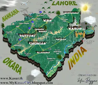
Located at 55 KM from Lahore. Some of its boundary is adjacent to India. On the
north of Kasur there is Lahore district, on the east and south-east by India,
on the south-west by Okara district and on the north-west by Nankana Sahib
District. Total area of Kasur district is 3,995 square kilometers and total
population of Kasur district is 40,84,286 as per 2023 census data. Zip code of Kasur is 55050.
There are following 4 Tehsils in district Kasur.
- Thesil Kasur
- Tehsil Kot Radha Kishan
- Tehsil Chunian
- Tehsil Pattoki
There are total
125 Union councils and 10 Municipal committees in district Kasur. Kasur
district covers 4 National assembly seats (NA131 to NA134) and 10 Provincial
assembly seats (PP-175 to PP-184).
History:
Kasur
become district in 1976 as earlier it was a one of Tehsil of district Lahore. Historically, Kasur is one of the oldest cities of
Pakistan. In ancient times, it was just a small settlement with Katcha houses
on the northern bank of the older river Beas. According to an estimate Kasur
was a big village in 1 AD.
- In 553 AD this was occupied by Khaweshgan.
- In 1020 AD, Kasur was included in the territory of Lahore, which was the capital of the state under Raja Jaipal.
- In 1526 AD, When Emperor Baber captured the whole of India, he gave this city to the Afghans as a token of their service towards his victory. During the reign of Shah Jahan and Aurangzeb, Kasur was glorified and every rich man constructed his own palace in Kasur.
- In May 1763, The Battle of Kasur, also referred to as the Sacking of Kasur, took place in which the Sikh joined forces to challenge the Afghan troops in Kasur. The Sikhs managed to conquer the city successfully and emerged victorious over the Afghan army.
- In 1794, two Pathan brothers, Nizam ud Din and Kutab ud Din expelled the Sikhs from Kasur and re-established the Pathan rule until 1807 when at last, Kutab ud Din was forced to give way to Ranjit Singh and retire to his territory at Mamdot, beyond the Sutlej River.
- In 1830 AD, Maharaja Ranjeet Singh captured Kasur and it was under Sikh role by the year 1847 when the British took over control of India.
- In 1807, The town of Kasur was incorporated in the Kingdom of Lahore by Ranjit Singh and had been a municipality since 1885. There is said to be seven tribes of Pathan who settled here sometimes during the reign of Moghal king Baber but more probably in 1560, during the times of his grandson Akbar. At that time the town is said to have a population of about 3,500.
 |
 |
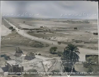
| Kamal Chishti Shrine Kasur in 1971 |
History related to area called “Rohy wal” (روہے وال).
History of the area is often
endorsed as being very ancient by quoting the mud filled town near it (1/2 km
away from District Headquarters), which was called Rohay Wal (روہے وال).
A tomb of a Muslim mystic Baba Kamal Chishti and some other graves are still
found at the top of these teelas, who was of mughal era and disciple of Baba
Fareed-ud-Din Ganj Shakar and Nizam-ud-Din Aulia. Many of these teelas has been
dug up and has been leveled to ground for encroachments and roads etc.
It is said that Rohay Wal (the
lost town) was once the main city and the current city was a suburb of that.
The city is built upon the high bank which marks the termination of the Majha
and looks down upon the lowlands of the Satluj hither.
It is a place of great antiquity
and is identified by the historians as one of the place visited by the Chinese
pilgrim, Howang Tsang in the 7th century BC but it does not appear in history
until late in the Muslim period when it was established as a Pashtun colony
near the northern/western bank of the Sutlej. These migrants entered the town
either in the reign of Babar or in that of his grandson Akbar and founded a
considerable principality with territory on both sides of the Satluj.
When the Sikhs rose to power,
they met great opposition from the Pashtuns of Kasur. The chiefs of the Bhangi
confederacy stormed the town in the 1763 and again in 1770 and although they
succeeded in holding the entire principality for a while, the Pashtun leaders
re-established their independence in 1794 and resisted many subsequent attacks.
Among the Pathans who settled here were certain Hasanzais,
whose descendents became the chiefs of the town and founded a considerable
principality, including territory on both banks of the Sutlej River.
The town of Kasur was then incorporated into the dominion of
Ranjit Singh. After the Sikhs, this area was taken over by the British. In
1867, the British constituted the Municipality of Kasur.
It remained a tehsil of Lahore District with an Extra
Assistant Commissioner in-charge of the sub division until 1st July 1976 when
it was made a district. Initially, the district comprised two sub divisions
namely Kasur and Chunian. Later on in 1992, the Government of Punjab created a
third sub division called Pattoki. While in 2008 another town Kot Radha Kishan
was notified as fourth tehsil (sub-division) of the district.
History of Name :
Historically the
city of Kasur was named by ancient Aryan tribe of Kambojas who migrated from
Mittani and Kussara and belonged to Ancient King Pithana of Mesopotamian
Kussara.
The town of Khudian was built by ancient Aryan Iranian
Kambojas of Kasur who claim descent from Saman Khuda. A village Khoda near
Khudian is also inhabited by Kambojah Clan. The same clan Kambojas also claims
to be offsprings of Kumbakarna and Rama.
Ancient town of Rajowal of Kambojas is also related to
Kambojas of Khemkaran. According to a traditional belief, Kasur was founded by
Prince Kusha, the son of Rama, while Lahore, called Lavapuri in ancient times,
was founded by his brother Prince Lava. Kasur had been allotted by the Mughals
to Pashtuns or Afghans of Kabul and still contains a colony of Pashtuns.
However the site was occupied by a Rajput town long before
the period of Muslim rule. According to some historians, the name Kasur is
derived from Kashawar, the same way Lahore is said to be taken from Lahawar.
Kush, the son of Ram Chander or Rama, is said to have founded Kasur like his
brother Loh or Lav is said to have founded Lahore.
However, some historians opine that Kasur is a Persian word
and a plural of "Kasar" or "Qasar" (meaning palace), which
the name was given during the times Kasur was a remarkable colony of Pathans,
perhaps the most remarkable on this side of Indus.
 |
| BRB Canal Bridge Ganda Singh 1947 |
Kots in Kasur
The city of Kasur is an aggregation of fortified hamlets,
called kots, small in themselves, but together forming a considerable town.
In 1592 Originally there were 12 principal residential
colonies which were built under the rule of Mogul Chapatti Genghis Khan's
descendant Jalal ud Din Muhammad Akbar in promulgation with the grace extended
from Moguls to Pathans.
The names of some Kots (کوٹ) are as follows:
- Kot Pacca Qila
- Kot Nawan Qila
- Kot Azam Khan
- Kot Ghulam Muhammad
- Kot Murad Khan
- Kot Haleem Khan
- Kot Peeraan
- Kot Fateh Din Khan
- Kot Usman Khan
- Kot Badar-ud-Din Khan
- Kot Ruken Din Khan
- Road Kot Kasur
Tourism:
There are many places for Tourism
and picnic in Kasur district, some of the famous places you can explore are
listed below.
- A Joint Check Post (JCP) at Ganda Singh Wala (Indo-Pak border) located at a distance of 18 Km from Kasur City.It is a major Tourist attraction because of the famous Guard Changing Ceremony everyday. People of Pakistan and India both enjoy this ceremony at the same time. It is same ceremony as Wahga Border Lahore.
 |
| Pakistani & Indian People Watching Guard Changing Ceremony at JCP kasur |
Picnic Points:
Apart
from the tourism places mentioned above there are some more places in Kasur
where you can have a picnic etc.
Shrines
Kasur is also called “City of Saints” because Many Ulama
belonged to Kasur district whose shrines are now located at various places in
Kasur. Names of some of the famous Shrines in district Kasur is as under.
- Shrine Hazrat Kamal Chisti
- Shrine Naqeebabad
- Shrine Hazrat Abdul Khaliq
- Shrine Hazrat Abbas Shah
- Shrine at village Bhalla
- Shrine Hazrat Abbas Shah Pattoki
- Shrine Hazrat Panny Shah Roshan Bheela
- Shrine Hazrat Sheikh Ilam Din Kasur
- Shrine Daim al Hazuri Kasuri
- Shrine Hazrat Imam Shah Bukhari
Food
The City Kasur is famous for its very spicy Fish, Kasuri Falooda, sweet dishes "Andrassa and Sohan Halwa and Specially for Kasuri Methi.
- Kasuri Fish
- Kasuri Faluda (فالودہ)
- Kasuri Andrasy (اندرسے)
- Kasuri Methi (میتھی)
 |
| Kasuri Faluda |
Famous personalities
Many famous personalities belong to Kasur district, some of the important
ones are mentioned below
- Hazrat Bulleh Shah
- Kasur is famous for saint Baba Bullay Shah (بلھے شاہ) whose tomb is in this city.
- Seth Abid Hussain
Famous political personalities from Kasur:
- Malik Muhammad Ahmad Khan (Malik Family of Kasur)
- Najam Sethi
- Rana Phool Muhammad (Rana Family of Kasur)
- Ch Manzoor
- Khurshid Mahmud Kasuri
- Rana Phool Muhammad Khan, served as caretaker chief minister for more than one year
- Rana Muhammad Iqbal served as Speaker Punjab Assembly
Famous personalities related to Music industry:
- Ustad Bade Ghulam Ali Khan
- Ustad Barkat Ali Khan
- Ustad Amanat Ali Khan
- Kasur is the birthplace of Noor Jehan, the famous Pakistani singer and actress who gained popularity in the 1950's.
Health
There is 1 Main Govt hospital of district Kasur called “Bulleh
Shah Hospital Kasur” (District Headquarter / DHQ Hospital Kasur). There are
also following 4 THQ Hospitals in district Kasur.
- THQ Hospital Roshan Bheela
- THQ Hospital Chunian
- THQ Hospital Kot Radha Kishan
- THQ Hospital Pattoki
Moreover, There is Cardiac Centre Chunian and Trauma Centre
Phool Nagar. There are total 11 RHCs (Rural Health centers) and 80 BHUs (Basic
Health Units) in district Kasur. Detail is as under.
There are also a number of private hospitals/ Health care centres in district Kasur.
Education in Kasur:
There are about 922 Primary Schools, 253 Elementary Schools, 169 High Schools and 14 Higher secondary Govt Schools in district Kasur. There are also 1000+ private schools in district Kasur. There are number of collages and other educational institutions are in Kasur.
There are also 2 Universities (Akhuwat University Kasur and UVAS Pattoki district Kasur) in Kasur. Moreover, There are also many private academies in Kasur where number of students are learning.
Agriculture
The farm area of the about district is 393,000 hectares and
the area under cultivation is about 295,000 hectares. The main crops grown in
the district are rice, cotton, sugarcane, wheat, corn and fodder etc depends on
land. For example land near Satluj river/ border area is famous for corn, Patatas,
Water melon, Strawberry fields. Land in
Mahja area famous for Sugarcane and other fields.
If we talk about water resources then there are 2 rivers
“Satulj river Kasur” and “Ravi river Kasur” passed from the boundary of Kasur
district. There are about 57 canals (irrigation channels) in district Kasur but
all of these canal links to BRBD link canal (near Bedian head). Total length of
these canals are about 371 miles.
Political of Kasur
District
Kasur plays a vital role in politics of Pakistan. Many prominent politicians
belong to Kasur district who have held important government positions at one
time or another. District Kasur covers 4 National Assembly seats and 10
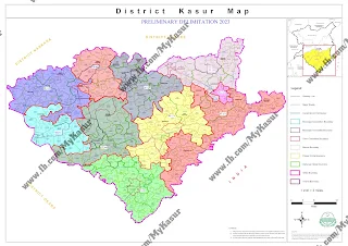
Provincial assembly seats. Maps of NA and PP constitutions of district Kasur is
as under.
In recent elections 2024, PMLN got 3 NA and 8 PP seats while PTI won 1 NA and 2 PP seats. Note that PTI candidates participated as an independent candidates in elections 2024. Here is a list of some of the famous politicians from District Kasur.
New NA PP area Map (Preliminary Delimitation) district Kasur in elections 2024
District Kasur covers National assembly Areas from NA 131, NA 132, NA 133, NA-134 and Provincial assembly Areas from PP 175, PP176, PP177, PP 178, PP 179, PP 180, PP 181, PP 182, PP 183, PP-184 in general elections 2024.
NA PP map full HD images are as under.
.jpg) |
| New NA PP areas Kasur elections 2024 |
District Administration:
Currently,
(from dated 12-Aug-2024), Captain (R) Aurangzeb Haider Khan is serving as Deputy Commissioner Kasur/
DC Kasur and Muhammad Essa Khan is serving as DPO Kasur (District Police Officer) from 08-May-2024.
Following Offices are serving in district Kasur.
- Election Commission of Pakistan/ ECP Office
- NADRA Office Kasur
- Passport Office Kasur
- Zakat Office Kasur
- Education Office Kasur
- Food department Office Kasur
- Auqaf Office Kasur
- Anti Corruption Office Kasur
- Social welfare office Kasur
- Wapda
- Agriculture
- Auqaf & Religious Affairs
- Punjab Bait-ul-Maal
- Excise office Kasur
- Finance
- Forest, Wildlife & Fisheries
- Specialized Healthcare and Medical Education
- Higher Education
- Housing, Urban Development & Public Health
- Human Rights & Minorities Affairs
- Industries, Commerce, Investment & Skills Development
- Information, Culture & Youth Affairs
- Irrigation
- Labor & Human Resource
- Literacy & Non-Formal Basic Education
- Livestock & Dairy Development
- Local Government & Community Development
- Mines & Minerals
- Planning & Development
- Punjab Police
- Population Welfare
- Transport Department
- Public Prosecution
- Board of Revenue
- Special Education
- School Education Department
- Technical Education & Vocational Training Authority
- Women Development
 |
| Railway Station Kasur |


